This product profile is currently unclaimed.
The listing is published on SaaSworthy, but the official vendor does not yet manage it. Are you part of the Iggy team? Claim this profile to manage and update your product information.
Iggy is a geospatial data, labelling and analytical tool that enables businesses to gather real-time location data into their apps. The tool can be added to users’ products in less than an hour and reduce the overall complexity levels in no time. This way companies get to easily focus on building a great product as per requirement. The software also turns out to be quite helpful in building extensive docs and a helpful community, where users can communicate with each other to share knowledge and help one another as well. Iggy’s exclusive toolkit makes businesses get access to simple endpoints that can be scaled with their applications. Admins also get to access more than 100 datasets and get notified about the new ones. Moreover, Iggy is quite easy and fast to implement. Thus complementing the most demanding workloads that individual businesses are going through. To implement Iggy, users just need to pass their locations to the API, select from the wide range of available data and get the data that they need for particular places.
Read more
Pricing
SW Score Breakdown
Platforms Supported
Organization Types Supported
API Support
Modes of Support
Spatial Analysis
Supports manipulation of geographical data or imagery for better geovisualization in a different context, applications, and operationsMap Creation
Helps in creating maps using less effort and in less timeLabeling
Supports adding labels to certain items for its quick and easy identificationInternet Mapping
Allows to store and display Internet topological data in a systematic wayGeocoding
Enables users to convert an address into spatial data to find the coordinates of an address or placeMap Sharing
Allows exchanging the created maps with others for better collaborationInteroperability
This feature enables the system to share resources with other system/software and make good use of the exchanged dataImage Management
Automates the graphical data management and monitoring tasks for easy accessibilityImage Exporting
Supports export of graphical data at different sizes and formatColor Coding
Allows highlighting different significant information by using different colors for easy identificationCensus Data Integration
Helps to collect census data from multiple sources and display it in a unified form in a single database3D Imagery
Supports stereoscopic imaging where a technique is used to record and display images by creating an illusion of depth in themFree Trial
Available
Trial Account Others
Features
Basic Account $25.00 $25.00 per month
Features
Custom Account Custom
Features
Screenshots of Vendor Pricing Page
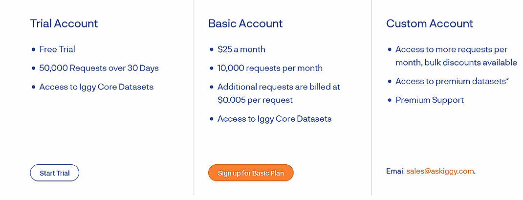
Disclaimer: The pricing details were last updated on 27/07/2021 from the vendor website and may be different from actual. Please confirm with the vendor website before purchasing.
Learn more about Iggy Pricing
92% SW Score The SW Score ranks the products within a particular category on a variety of parameters, to provide a definite ranking system. Read more
87% SW Score The SW Score ranks the products within a particular category on a variety of parameters, to provide a definite ranking system. Read more
96% SW Score The SW Score ranks the products within a particular category on a variety of parameters, to provide a definite ranking system. Read more
92% SW Score The SW Score ranks the products within a particular category on a variety of parameters, to provide a definite ranking system. Read more
77% SW Score The SW Score ranks the products within a particular category on a variety of parameters, to provide a definite ranking system. Read more
90% SW Score The SW Score ranks the products within a particular category on a variety of parameters, to provide a definite ranking system. Read more
76% SW Score The SW Score ranks the products within a particular category on a variety of parameters, to provide a definite ranking system. Read more
94% SW Score The SW Score ranks the products within a particular category on a variety of parameters, to provide a definite ranking system. Read more
Iggy API Teaser: ...
What is Iggy used for?
Iggy is Geographic Information System Software. Iggy offers the following functionalities:
Learn more about Iggy features.
What are the top alternatives for Iggy?
Here`s a list of the best alternatives for Iggy:
Does Iggy provide API?
Yes, Iggy provides API.
Vendor Details
San Francisco, CaliforniaSocial Media Handles
This research is curated from diverse authoritative sources; feel free to share your feedback at [email protected]
Looking for the right SaaS
We can help you choose the best SaaS for your specific requirements. Our in-house experts will assist you with their hand-picked recommendations.
Want more customers?
Our experts will research about your product and list it on SaaSworthy for FREE.
