This product profile is currently unclaimed.
The listing is published on SaaSworthy, but the official vendor does not yet manage it. Are you part of the eSpatial team? Claim this profile to manage and update your product information.
This SaaS web-based geographic information system software can easily transform your valuable data into easy-to-understand visual maps. It gives sophisticated analysis tools, visually appealing styling options, and offers seamless integration with Salesforce. It is a highly collaborative tool. It has advanced location analytics that facilitates data filtering and segmentation to connect business activity directly to a destination. eSpatial includes a long list of useful GIS features, which include census data integration, geocoding, interoperability, spatial analysis, internet mapping etc. You can do labeling, colour coding, export images, create maps and share them.
Read more


Pricing
SW Score Breakdown
Platforms Supported
Organization Types Supported
API Support
Modes of Support
Spatial Analysis
Supports manipulation of geographical data or imagery for better geovisualization in a different context, applications, and operationsMap Sharing
Allows exchanging the created maps with others for better collaborationMap Creation
Helps in creating maps using less effort and in less timeLabeling
Supports adding labels to certain items for its quick and easy identificationInteroperability
This feature enables the system to share resources with other system/software and make good use of the exchanged dataInternet Mapping
Allows to store and display Internet topological data in a systematic wayImage Exporting
Supports export of graphical data at different sizes and formatGeocoding
Enables users to convert an address into spatial data to find the coordinates of an address or placeColor Coding
Allows highlighting different significant information by using different colors for easy identificationCensus Data Integration
Helps to collect census data from multiple sources and display it in a unified form in a single databaseImage Management
Automates the graphical data management and monitoring tasks for easy accessibility3D Imagery
Supports stereoscopic imaging where a technique is used to record and display images by creating an illusion of depth in themFree Trial
Not available
Pro $1,295.00 $1,295.00 per year
Features
Optional extras
Team $2,995.00 $2,995.00 per year
Includes Pro plan features, plus
Optional extras
Team Territory Manager $4,995.00 $4,995.00 per year
All the Team plan features
Optional extras
Enterprise Custom
All the Team Territory Manager plan features
Optional extras
Screenshots of Vendor Pricing Page
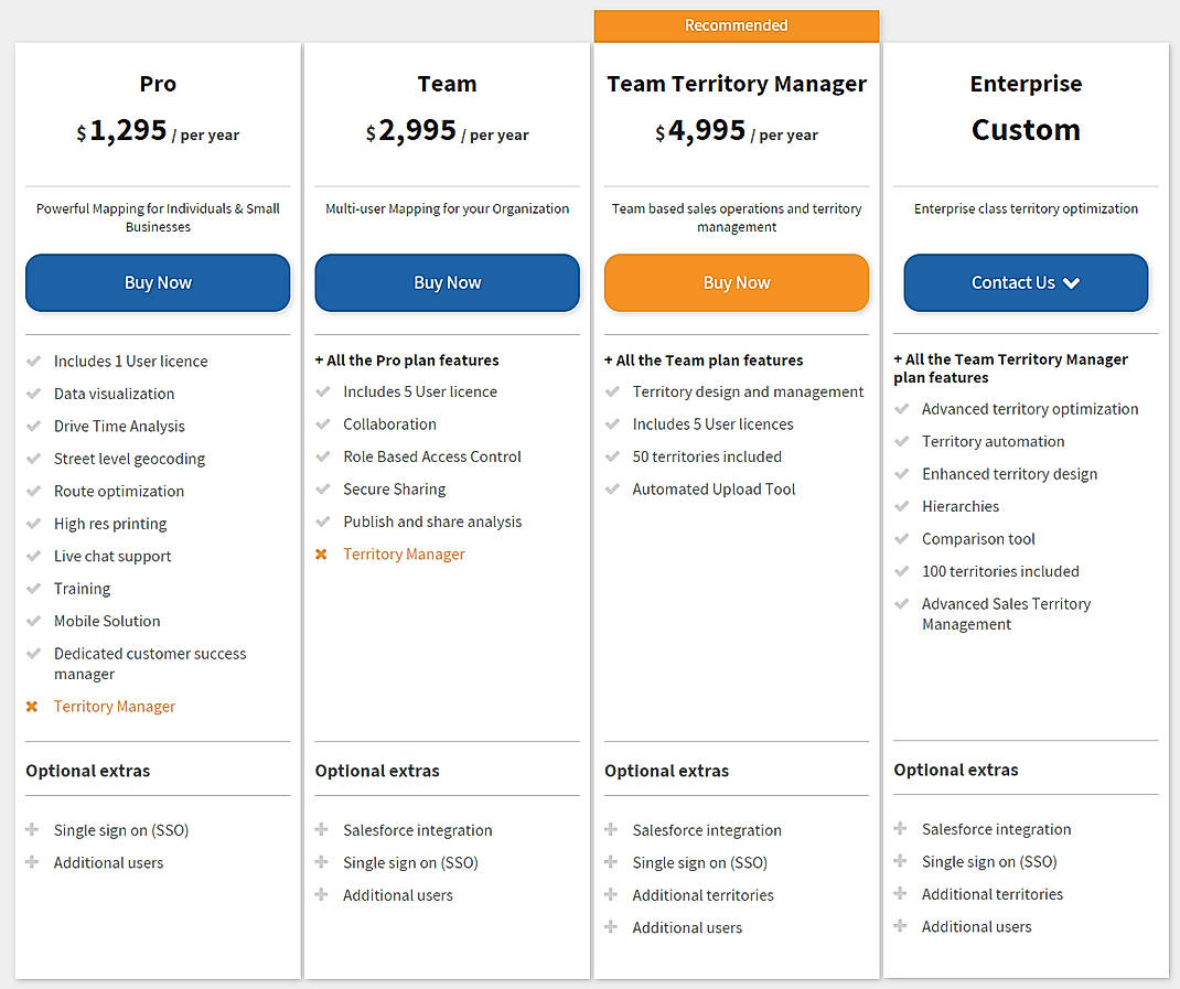
Learn more about eSpatial Pricing
93% SW Score The SW Score ranks the products within a particular category on a variety of parameters, to provide a definite ranking system. Read more
92% SW Score The SW Score ranks the products within a particular category on a variety of parameters, to provide a definite ranking system. Read more
78% SW Score The SW Score ranks the products within a particular category on a variety of parameters, to provide a definite ranking system. Read more
87% SW Score The SW Score ranks the products within a particular category on a variety of parameters, to provide a definite ranking system. Read more
80% SW Score The SW Score ranks the products within a particular category on a variety of parameters, to provide a definite ranking system. Read more
94% SW Score The SW Score ranks the products within a particular category on a variety of parameters, to provide a definite ranking system. Read more
90% SW Score The SW Score ranks the products within a particular category on a variety of parameters, to provide a definite ranking system. Read more
77% SW Score The SW Score ranks the products within a particular category on a variety of parameters, to provide a definite ranking system. Read more
Introducing eSpat...

How To Style Your...

Regional Heat Map...

Heat Map

Product B Sales

Product B Sales 2

Pin Maps
What is eSpatial used for?
eSpatial is Geographic Information System Software. eSpatial offers the following functionalities:
Learn more about eSpatial features.
What are the top alternatives for eSpatial?
Here`s a list of the best alternatives for eSpatial:
Does eSpatial provide API?
Yes, eSpatial provides API.
Vendor Details
Herndon, Virginia Founded : 1997Social Media Handles


This research is curated from diverse authoritative sources; feel free to share your feedback at [email protected]
Looking for the right SaaS
We can help you choose the best SaaS for your specific requirements. Our in-house experts will assist you with their hand-picked recommendations.
Want more customers?
Our experts will research about your product and list it on SaaSworthy for FREE.


