This product profile is currently unclaimed.
The listing is published on SaaSworthy, but the official vendor does not yet manage it. Are you part of the IGISMAP team? Claim this profile to manage and update your product information.
Introducing IGISMAP the powerful web platform designed to help them tackle all their daily geospatial tasks and projects with ease. This platform provides them with multiple GIS applications, a leading edge user interface, and unparalleled pursuits in the field of analytics. With IGISMAP, them can trust this reliable and comprehensive GIS solutions to meet the demands of their intense projects. They offer a variety of applications to help them craft complex reports, consolidate immense amounts of data, and track results of their tasks. This user friendly platform allows them to quickly and efficiently multitask between unlimited layered maps and surveys giving them the most advanced tools to maximize the potential of their org's geospatial exploration. Whether they're new to the field or experienced in geospatial engineering, IGISMAP will be sure to make their work flow smoothly and efficiently. With this intuitive interface and user features, them can quickly and easily access all their data in one place. Let IGISMAP lead them to greater success with its innovative GIS solutions.
Read more
Pricing
SW Score Breakdown
Platforms Supported
Organization Types Supported
API Support
Modes of Support
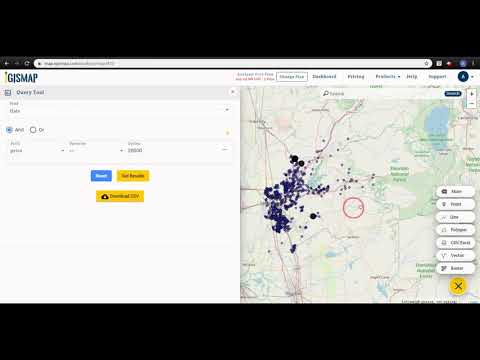
Spatial Analysis
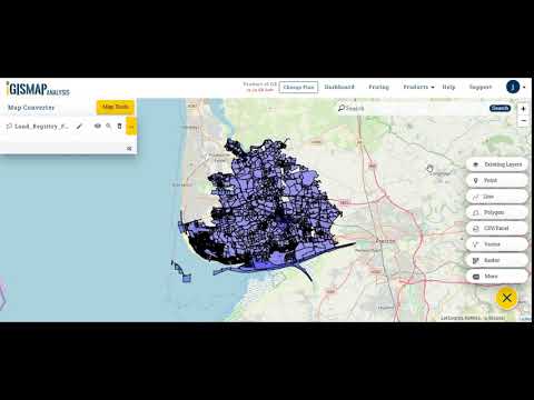
Supports manipulation of geographical data or imagery for better geovisualization in a different context, applications, and operationsMap Sharing
Allows exchanging the created maps with others for better collaborationLabeling
Supports adding labels to certain items for its quick and easy identificationInteroperability
This feature enables the system to share resources with other system/software and make good use of the exchanged dataGeocoding
Enables users to convert an address into spatial data to find the coordinates of an address or placeMap Creation
Helps in creating maps using less effort and in less timeInternet Mapping
Allows to store and display Internet topological data in a systematic wayImage Management
Automates the graphical data management and monitoring tasks for easy accessibilityImage Exporting
Supports export of graphical data at different sizes and formatColor Coding
Allows highlighting different significant information by using different colors for easy identificationCensus Data Integration
Helps to collect census data from multiple sources and display it in a unified form in a single database3D Imagery
Supports stereoscopic imaging where a technique is used to record and display images by creating an illusion of depth in themFree Trial
Not available
Free Free
Features
Basic $21.00 $29.00 per month
Features
Standard $29.00 $49.00 per month
Features
Business $58.00 $99.00 per month
Features
Screenshots of Vendor Pricing Page
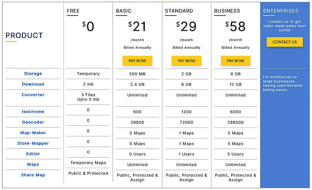
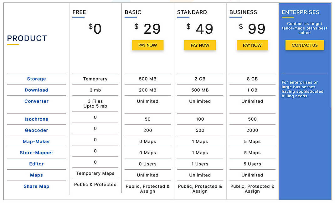
Learn more about IGISMAP Pricing
94% SW Score The SW Score ranks the products within a particular category on a variety of parameters, to provide a definite ranking system. Read more
90% SW Score The SW Score ranks the products within a particular category on a variety of parameters, to provide a definite ranking system. Read more
81% SW Score The SW Score ranks the products within a particular category on a variety of parameters, to provide a definite ranking system. Read more
78% SW Score The SW Score ranks the products within a particular category on a variety of parameters, to provide a definite ranking system. Read more
91% SW Score The SW Score ranks the products within a particular category on a variety of parameters, to provide a definite ranking system. Read more
78% SW Score The SW Score ranks the products within a particular category on a variety of parameters, to provide a definite ranking system. Read more
72% SW Score The SW Score ranks the products within a particular category on a variety of parameters, to provide a definite ranking system. Read more
78% SW Score The SW Score ranks the products within a particular category on a variety of parameters, to provide a definite ranking system. Read more
Municipal GIS Ser...
Convert GML to KM...
Query GIS Map Dat...
What is IGISMAP used for?
IGISMAP is Geographic Information System Software. IGISMAP offers the following functionalities:
Learn more about IGISMAP features.
What are the top alternatives for IGISMAP?
Here`s a list of the best alternatives for IGISMAP:
Does IGISMAP provide API?
Yes, IGISMAP provides API.
Vendor Details
Not available
Social Media Handles
This research is curated from diverse authoritative sources; feel free to share your feedback at [email protected]
Looking for the right SaaS
We can help you choose the best SaaS for your specific requirements. Our in-house experts will assist you with their hand-picked recommendations.
Want more customers?
Our experts will research about your product and list it on SaaSworthy for FREE.
