This product profile is currently unclaimed.
The listing is published on SaaSworthy, but the official vendor does not yet manage it. Are you part of the BatchGeo team? Claim this profile to manage and update your product information.
BatchGeo is a data map-making tool that offers companies the fastest way to create Google Maps with their data. It is an intuitive tool where Excel documents can be converted into interactive maps with just a click of a button. The dynamic thumbnail versions of these maps can be included on users’ websites so that customers can quickly preview the map and the associated link. BatchGeo is capable of converting open data available in tabular format to Google maps so that it can be read easily. To create data maps in simplified formats, users can break and divide the entire data into groups. These groups make it easy for users to find the required data quickly, by filtering out the unwanted information. The data maps created with BatchGeo also help companies to make data analysis, just like they do with the data present in the form of charts and graphs. Also, with this tool, users can map customers, suppliers, leads and other data to simplify their various business processes.
Read more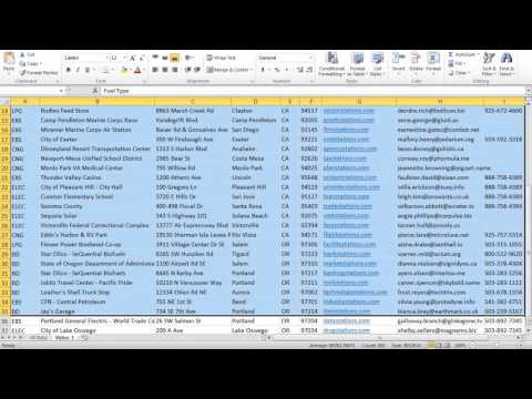
Pricing
SW Score Breakdown
Platforms Supported
Organization Types Supported
API Support
Modes of Support
Spatial Analysis
Supports manipulation of geographical data or imagery for better geovisualization in a different context, applications, and operationsMap Sharing
Allows exchanging the created maps with others for better collaborationMap Creation
Helps in creating maps using less effort and in less timeInternet Mapping
Allows to store and display Internet topological data in a systematic wayImage Exporting
Supports export of graphical data at different sizes and formatGeocoding
Enables users to convert an address into spatial data to find the coordinates of an address or placeColor Coding
Allows highlighting different significant information by using different colors for easy identificationLabeling
Supports adding labels to certain items for its quick and easy identificationInteroperability
This feature enables the system to share resources with other system/software and make good use of the exchanged dataImage Management
Automates the graphical data management and monitoring tasks for easy accessibilityCensus Data Integration
Helps to collect census data from multiple sources and display it in a unified form in a single database3D Imagery
Supports stereoscopic imaging where a technique is used to record and display images by creating an illusion of depth in themFree Trial
Not available
BatchGeo Pro $99.00 $99.00 per month
Features
Screenshots of Vendor Pricing Page
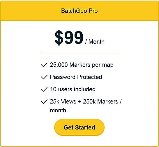
Disclaimer: The pricing details were last updated on 31/03/2021 from the vendor website and may be different from actual. Please confirm with the vendor website before purchasing.
Learn more about BatchGeo Pricing
90% SW Score The SW Score ranks the products within a particular category on a variety of parameters, to provide a definite ranking system. Read more
77% SW Score The SW Score ranks the products within a particular category on a variety of parameters, to provide a definite ranking system. Read more
78% SW Score The SW Score ranks the products within a particular category on a variety of parameters, to provide a definite ranking system. Read more
92% SW Score The SW Score ranks the products within a particular category on a variety of parameters, to provide a definite ranking system. Read more
92% SW Score The SW Score ranks the products within a particular category on a variety of parameters, to provide a definite ranking system. Read more
87% SW Score The SW Score ranks the products within a particular category on a variety of parameters, to provide a definite ranking system. Read more
94% SW Score The SW Score ranks the products within a particular category on a variety of parameters, to provide a definite ranking system. Read more
80% SW Score The SW Score ranks the products within a particular category on a variety of parameters, to provide a definite ranking system. Read more
BatchGeo MapHow t...
What is BatchGeo used for?
BatchGeo is Geographic Information System Software. BatchGeo offers the following functionalities:
Learn more about BatchGeo features.
What are the top alternatives for BatchGeo?
Here`s a list of the best alternatives for BatchGeo:
Does BatchGeo provide API?
No, BatchGeo does not provide API.
Vendor Details
Portland, OregonSocial Media Handles
This research is curated from diverse authoritative sources; feel free to share your feedback at [email protected]
Looking for the right SaaS
We can help you choose the best SaaS for your specific requirements. Our in-house experts will assist you with their hand-picked recommendations.
Want more customers?
Our experts will research about your product and list it on SaaSworthy for FREE.
