This product profile is currently unclaimed.
The listing is published on SaaSworthy, but the official vendor does not yet manage it. Are you part of the Maptitude team? Claim this profile to manage and update your product information.
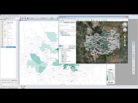
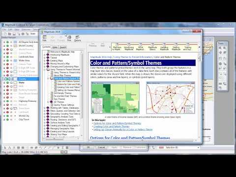
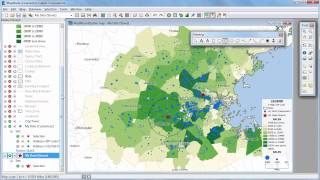
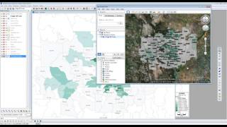
This cloud-based geographical information software can also be considered as a location intelligence software. Maptitude is loaded with almost all significant and useful GIS features to enhance its utility value. It supports creation of highly interactive maps that you can easily share as well for better collaboration with your team members. In addition to image management & exporting, Maptitude also features 3D imagery and spatial analysis. Color coding and labelling enables you to spot desired items on maps quicker. Geocoding and census data integration capabilities accentuate its efficiency. Internet mapping is possible with Maptitude. Trade area analysis is possible.
Read more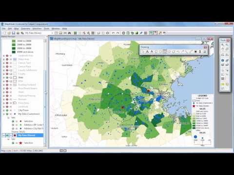
Pricing
SW Score Breakdown
Platforms Supported
Organization Types Supported
API Support
Modes of Support
Spatial Analysis
Supports manipulation of geographical data or imagery for better geovisualization in a different context, applications, and operationsMap Sharing
Allows exchanging the created maps with others for better collaborationMap Creation
Helps in creating maps using less effort and in less timeLabeling
Supports adding labels to certain items for its quick and easy identificationInteroperability
This feature enables the system to share resources with other system/software and make good use of the exchanged dataInternet Mapping
Allows to store and display Internet topological data in a systematic wayImage Management
Automates the graphical data management and monitoring tasks for easy accessibilityImage Exporting
Supports export of graphical data at different sizes and formatGeocoding
Enables users to convert an address into spatial data to find the coordinates of an address or placeColor Coding
Allows highlighting different significant information by using different colors for easy identificationCensus Data Integration
Helps to collect census data from multiple sources and display it in a unified form in a single database3D Imagery
Supports stereoscopic imaging where a technique is used to record and display images by creating an illusion of depth in themFree Trial
Available
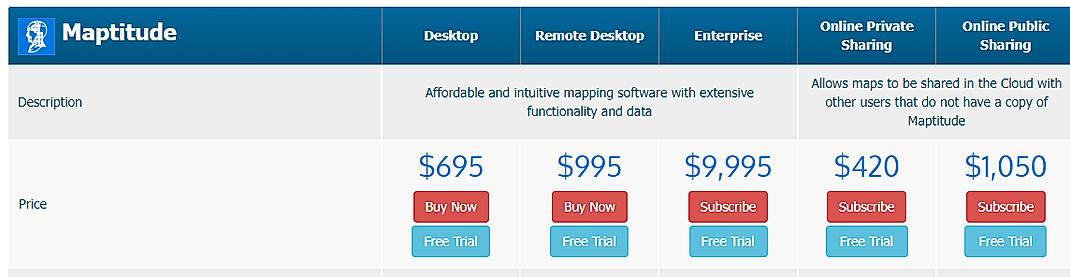
Desktop $695.00 $695.00 One Time Payment
DESKTOP
Remote Desktop $995.00 $995.00 One Time Payment
REMOTE DESKTOP
Enterprise $9,995.00 $9,995.00 One Time Payment
ENTERPRISE
Online Private Sharing $420.00 $420.00 One Time Payment
ONLINE PRIVATE SHARING
Online Public Sharing $1,050.00 $1,050.00 One Time Payment
ONLINE PUBLIC SHARING
Screenshots of Vendor Pricing Page
Learn more about Maptitude Pricing
94% SW Score The SW Score ranks the products within a particular category on a variety of parameters, to provide a definite ranking system. Read more
78% SW Score The SW Score ranks the products within a particular category on a variety of parameters, to provide a definite ranking system. Read more
90% SW Score The SW Score ranks the products within a particular category on a variety of parameters, to provide a definite ranking system. Read more
81% SW Score The SW Score ranks the products within a particular category on a variety of parameters, to provide a definite ranking system. Read more
90% SW Score The SW Score ranks the products within a particular category on a variety of parameters, to provide a definite ranking system. Read more
72% SW Score The SW Score ranks the products within a particular category on a variety of parameters, to provide a definite ranking system. Read more
70% SW Score The SW Score ranks the products within a particular category on a variety of parameters, to provide a definite ranking system. Read more
92% SW Score The SW Score ranks the products within a particular category on a variety of parameters, to provide a definite ranking system. Read more
78% SW Score The SW Score ranks the products within a particular category on a variety of parameters, to provide a definite ranking system. Read more
Creating Maptitud...
Introduction to M...
Maptitude 2018 In...
What is Maptitude used for?
Maptitude is Geographic Information System Software. Maptitude offers the following functionalities:
Learn more about Maptitude features.
What are the top alternatives for Maptitude?
Here`s a list of the best alternatives for Maptitude:
Does Maptitude provide API?
Yes, Maptitude provides API.
Vendor Details
Suite, MassachusettsSocial Media Handles
This research is curated from diverse authoritative sources; feel free to share your feedback at [email protected]
Looking for the right SaaS
We can help you choose the best SaaS for your specific requirements. Our in-house experts will assist you with their hand-picked recommendations.
Want more customers?
Our experts will research about your product and list it on SaaSworthy for FREE.