76% SW Score The SW Score ranks the products within a particular category on a variety of parameters, to provide a definite ranking system. Read more
Trouble Free Online GIS Mapping
This product profile is currently unclaimed.
The listing is published on SaaSworthy, but the official vendor does not yet manage it. Are you part of the IGISMAP team? Claim this profile to manage and update your product information.
Free Trial
Not available
The Average Cost of a basic Geographic Information System Software plan is $30 per month.
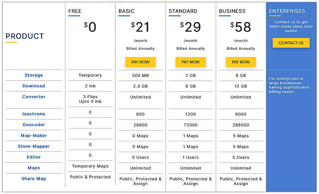
IGISMAP pricing starts at $21/month, which is 30% lower than similar services.
35% of Geographic Information System Software offer a Free Trial , while 28% offer a Freemium Model .
Free Free
Features
Basic $21.00 $29.00 per month
Features
Standard $29.00 $49.00 per month
Features
Business $58.00 $99.00 per month
Features
Screenshots of Vendor Pricing Page
How much does IGISMAP cost?
The pricing for IGISMAP starts at $21.0 per month. IGISMAP has 3 different plans:
IGISMAP also offers a Free Plan with limited features.
Learn more about IGISMAP pricing.
Does IGISMAP offer a free plan?
Yes, IGISMAP offers a free plan.
Learn more about IGISMAP pricing.
| Product Name | Starting Price ($) | Billed | Unit | Free Trial | Learn More |
|---|---|---|---|---|---|
|
|
21 | per month | - | IGISMAP Pricing | |
|
|
100 | per year | - | ArcGIS Online Pricing | |
|
|
1295 | per year | - | eSpatial Pricing | |
|
|
- | - | - | 3-GIS Pricing | |
|
|
- | - | - | Agile GIS Pricing | |
|
|
600 | per year | per user | Map Business Online Pricing | |
|
|
39 | per month | - | Mango Pricing | |
|
|
- | - | - | ArcGIS Instant Apps Pricing | |
|
|
- | - | - | Geoconcept GIS Pricing | |
|
|
- | - | - | 21stCenturyGIS Pricing |
98% SW Score The SW Score ranks the products within a particular category on a variety of parameters, to provide a definite ranking system. Read more
95% SW Score The SW Score ranks the products within a particular category on a variety of parameters, to provide a definite ranking system. Read more
94% SW Score The SW Score ranks the products within a particular category on a variety of parameters, to provide a definite ranking system. Read more
92% SW Score The SW Score ranks the products within a particular category on a variety of parameters, to provide a definite ranking system. Read more
90% SW Score The SW Score ranks the products within a particular category on a variety of parameters, to provide a definite ranking system. Read more
86% SW Score The SW Score ranks the products within a particular category on a variety of parameters, to provide a definite ranking system. Read more
84% SW Score The SW Score ranks the products within a particular category on a variety of parameters, to provide a definite ranking system. Read more
83% SW Score The SW Score ranks the products within a particular category on a variety of parameters, to provide a definite ranking system. Read more
87% SW Score The SW Score ranks the products within a particular category on a variety of parameters, to provide a definite ranking system. Read more
92% SW Score The SW Score ranks the products within a particular category on a variety of parameters, to provide a definite ranking system. Read more
83% SW Score The SW Score ranks the products within a particular category on a variety of parameters, to provide a definite ranking system. Read more
78% SW Score The SW Score ranks the products within a particular category on a variety of parameters, to provide a definite ranking system. Read more
92% SW Score The SW Score ranks the products within a particular category on a variety of parameters, to provide a definite ranking system. Read more
80% SW Score The SW Score ranks the products within a particular category on a variety of parameters, to provide a definite ranking system. Read more
74% SW Score The SW Score ranks the products within a particular category on a variety of parameters, to provide a definite ranking system. Read more
83% SW Score The SW Score ranks the products within a particular category on a variety of parameters, to provide a definite ranking system. Read more
98% SW Score The SW Score ranks the products within a particular category on a variety of parameters, to provide a definite ranking system. Read more
Spatial Analysis
Supports manipulation of geographical data or imagery for better geovisualization in a different context, applications, and operationsMap Sharing
Allows exchanging the created maps with others for better collaborationLabeling
Supports adding labels to certain items for its quick and easy identificationInteroperability
This feature enables the system to share resources with other system/software and make good use of the exchanged dataGeocoding
Enables users to convert an address into spatial data to find the coordinates of an address or placeMap Creation
Helps in creating maps using less effort and in less timeInternet Mapping
Allows to store and display Internet topological data in a systematic wayImage Management
Automates the graphical data management and monitoring tasks for easy accessibilityImage Exporting
Supports export of graphical data at different sizes and formatColor Coding
Allows highlighting different significant information by using different colors for easy identificationCensus Data Integration
Helps to collect census data from multiple sources and display it in a unified form in a single database3D Imagery
Supports stereoscopic imaging where a technique is used to record and display images by creating an illusion of depth in themLooking for the right SaaS
We can help you choose the best SaaS for your specific requirements. Our in-house experts will assist you with their hand-picked recommendations.
Want more customers?
Our experts will research about your product and list it on SaaSworthy for FREE.
