This product profile is currently unclaimed.
The listing is published on SaaSworthy, but the official vendor does not yet manage it. Are you part of the Farmapper team? Claim this profile to manage and update your product information.
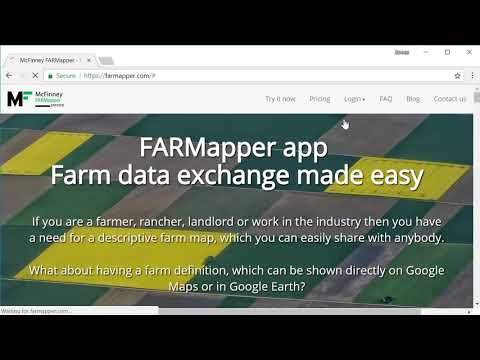
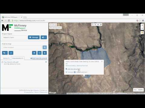
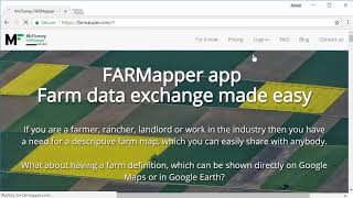
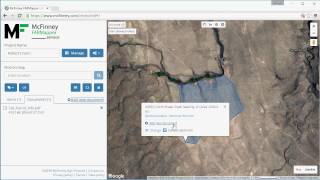
Farmapper is a mapping app for the farming industry that has been built for farmers, ranchers, landlords, and other notable stakeholders in agriculture. It makes it easy for them to build a farm data exchange system with a descriptive farm map. The farm can be directly depicted on global platforms such as Google Maps and Google Earth. Users can draw the map and built it with the help of preloaded legal description shapes while adding customizing it through stickers, colors, and more. They can also add range allotments and import polygon shapes. By creating and sharing listings for multiple categories like sales, equipment, and rent. Users can add information to their lands like deeds, legal descriptions, photos, and any other file that they want. And with a dedicated community around the product, they can also share the project with other users with specific restrictions such as read-only.
Read more


Pricing
SW Score Breakdown
Platforms Supported
Organization Types Supported
API Support
Modes of Support
Spatial Analysis
Supports manipulation of geographical data or imagery for better geovisualization in a different context, applications, and operationsMap Sharing
Allows exchanging the created maps with others for better collaborationMap Creation
Helps in creating maps using less effort and in less timeLabeling
Supports adding labels to certain items for its quick and easy identificationInteroperability
This feature enables the system to share resources with other system/software and make good use of the exchanged dataInternet Mapping
Allows to store and display Internet topological data in a systematic wayImage Management
Automates the graphical data management and monitoring tasks for easy accessibilityImage Exporting
Supports export of graphical data at different sizes and formatGeocoding
Enables users to convert an address into spatial data to find the coordinates of an address or placeColor Coding
Allows highlighting different significant information by using different colors for easy identificationCensus Data Integration
Helps to collect census data from multiple sources and display it in a unified form in a single database3D Imagery
Supports stereoscopic imaging where a technique is used to record and display images by creating an illusion of depth in themFree Trial
Not available
Pioneer Free
Features
Homesteader $10.00 $10.00 per month
$100 per Year billed Annually
Features
Land Baron $20.00 $20.00 per month
$200 per Year billed Annually
Features
Unlimited $50.00 $50.00 per month
$500 per Year billed Annually
Features
Screenshots of Vendor Pricing Page
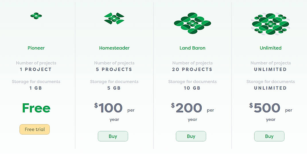
Disclaimer: The pricing details were last updated on 23/05/2019 from the vendor website and may be different from actual. Please confirm with the vendor website before purchasing.
Learn more about Farmapper Pricing
92% SW Score The SW Score ranks the products within a particular category on a variety of parameters, to provide a definite ranking system. Read more
87% SW Score The SW Score ranks the products within a particular category on a variety of parameters, to provide a definite ranking system. Read more
78% SW Score The SW Score ranks the products within a particular category on a variety of parameters, to provide a definite ranking system. Read more
80% SW Score The SW Score ranks the products within a particular category on a variety of parameters, to provide a definite ranking system. Read more
90% SW Score The SW Score ranks the products within a particular category on a variety of parameters, to provide a definite ranking system. Read more
92% SW Score The SW Score ranks the products within a particular category on a variety of parameters, to provide a definite ranking system. Read more
76% SW Score The SW Score ranks the products within a particular category on a variety of parameters, to provide a definite ranking system. Read more
74% SW Score The SW Score ranks the products within a particular category on a variety of parameters, to provide a definite ranking system. Read more
83% SW Score The SW Score ranks the products within a particular category on a variety of parameters, to provide a definite ranking system. Read more
74% SW Score The SW Score ranks the products within a particular category on a variety of parameters, to provide a definite ranking system. Read more
Getting Started w...
Farm Maps in the ...
How to use tracts...

Farmapper screenshot

Farmapper screenshot

Farmapper screenshot

Farmapper screenshot

Farmapper screenshot

Farmapper screenshot
What is Farmapper used for?
Farmapper is Geographic Information System Software. Farmapper offers the following functionalities:
Learn more about Farmapper features.
What are the top alternatives for Farmapper?
Here`s a list of the best alternatives for Farmapper:
Does Farmapper provide API?
No, Farmapper does not provide API.
Vendor Details
Boise, ID - 83702Social Media Handles
This research is curated from diverse authoritative sources; feel free to share your feedback at [email protected]
Looking for the right SaaS
We can help you choose the best SaaS for your specific requirements. Our in-house experts will assist you with their hand-picked recommendations.
Want more customers?
Our experts will research about your product and list it on SaaSworthy for FREE.


