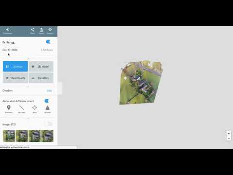
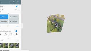
Capture the actual reality irrespective of the altitude, from any angle
This product profile is currently unclaimed.
The listing is published on SaaSworthy, but the official vendor does not yet manage it. Are you part of the DroneDeploy team? Claim this profile to manage and update your product information.
DroneDeploy is a drone mapping software that can be used to extract complete visual data for the interior and exterior of a particular site or building irrespective of, angle and altitude. Organizations from different industries like agriculture, solar energy, construction, mining & quarries, roofing, inspection, oil & gas etc, have found this software very useful for their daily business. The solution offers adequate support to enterprises in every step, starting from drone fleet monitoring to complete site analysis and documentation. DroneDeploy, with its advanced technology, enables enterprises with a robust digital reconstruction mechanism. That is capable of streamlining multiple processes besides simplifying their workflows. Further, the software is equipped with a powerful security system, offering active compatibility with PCI, GDPR, ISO 27001 and EU Privacy laws, safeguarding its user’s data. DroneDeploy partners with top-rated tools like SAP, DropBox, GoogleDrive etc, ensuring efficient, smooth and successful business operations.
Read more


Pricing
Platforms Supported
Organization Types Supported
API Support
Modes of Support
Free Trial
Available
No Credit Card Required, Get Started for Free
DroneDeploy Unified Plan Custom
Document your sites from every angle with drones, robots, 360 cameras, fixed cameras and smartphones all in one AI-powered platform.
DroneDeploy Ground Custom
Walk sites with 360 cameras, capture and organize photos, overlay maps onto floor plans, compare site conditions to BIM and share easily.
Features
DroneDeploy Aerial Custom
Fly commercial drones, capture and organize photos, generate maps and inspection reports, and share easily.
Features
Flight & Analysis Plan $4,188.00 $4,188.00 per year
Individual Pilots
Features
Ground capture processing not included
Ag Lite Plan $1,908.00 $1,908.00 per year
Agriculture Pilots
Features
Advanced Flight & Analysis Plan Custom
Individual Pilots
Features
Ground capture processing not included
Screenshots of Vendor Pricing Page

Learn more about DroneDeploy Pricing
79% SW Score The SW Score ranks the products within a particular category on a variety of parameters, to provide a definite ranking system. Read more
Featured71% SW Score The SW Score ranks the products within a particular category on a variety of parameters, to provide a definite ranking system. Read more
Installing and Us...

DroneDeploy: The ...

Live Map

Troubleshooting f...

Comparison

Autodesk BIM 360

Dashboard
Is Pix4D better than DroneDeploy?
Different strengths. Pix4D excels at high-precision photogrammetry and offline processing. DroneDeploy shines for ease of use, cloud workflows, construction progress, and analytics. Choose based on your mapping workload.
Is DroneDeploy good?
Yes for construction, roofing, and inspections that need quick cloud processing, annotations, and reporting. It is a private company, so there is no public stock price.
What are the top alternatives for DroneDeploy?
Does DroneDeploy provide API?
Yes, DroneDeploy provides API.
Vendor Details
San Francisco, California Founded : 2013Social Media Handles

This research is curated from diverse authoritative sources; feel free to share your feedback at [email protected]
Looking for the right SaaS
We can help you choose the best SaaS for your specific requirements. Our in-house experts will assist you with their hand-picked recommendations.
Want more customers?
Our experts will research about your product and list it on SaaSworthy for FREE.


