Mapbox |
88% SW Score The SW Score ranks the products within a particular category on a variety of parameters, to provide a definite ranking system. Read more
Visit Website
|
84% SW Score The SW Score ranks the products within a particular category on a variety of parameters, to provide a definite ranking system. Read more
Visit Website
|
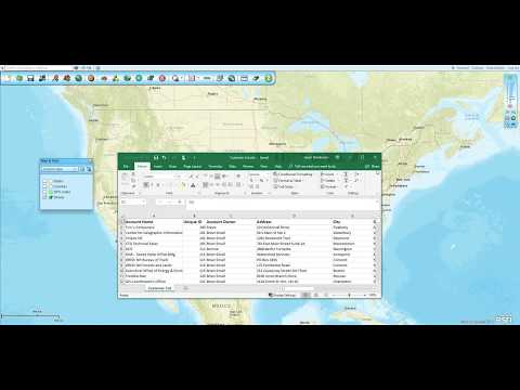
| Description | This is a cloud-based SaaS geographical information system software that comes packed with multiple GIS features. Plus, this software also includes several heatmap as well as sales force automation functionalities. It features a dashboard, embeddable maps, spatial analysis, internet mapping, dynamic maps, territorial mapping etc. The software has census data integration, geocoding and image exporting capabilities. Color coding and labelling facilitates easy detection of items you are looking for. Using Map Business Online tool you can create and also share interactive maps. It supports interoperability. It further helps in managing territory, campaigns, field sales and leads. Read more | PolicyMap offers easy-to-use online mapping with data on demographics, real estate, health, jobs and more in communities across the US. From the classroom to the boardroom, thousands of organizations trust PolicyMap to find the right data for their research, market studies, business planning, site selection, grant applications and impact analysis. The most location data on the web curated, cleaned, standardized, and always updated. PolicyMap products are powered by our growing and current library of indicators, from more than 150 authoritative public and proprietary sources. Read more |
| Pricing Options |
|
|
| SW Score & Breakdown |
88% SW Score The SW Score ranks the products within a particular category on a variety of parameters, to provide a definite ranking system. Read more
|
84% SW Score The SW Score ranks the products within a particular category on a variety of parameters, to provide a definite ranking system. Read more
|
| Total Features |
10 Features
|
9 Features
|
| Common Features for All |
3D Imagery
Census Data Integration
Color Coding
Geocoding
Image Exporting
Internet Mapping
Interoperability
Labeling
Map Creation
Map Sharing
Spatial Analysis
|
3D Imagery
Census Data Integration
Color Coding
Geocoding
Image Exporting
Internet Mapping
Interoperability
Labeling
Map Creation
Map Sharing
Spatial Analysis
|
| Organization Types Supported |
|
|
| Platforms Supported |
|
|
| Modes of Support |
|
|
| API Support |
|
|
| User Rating |
|
|
| Ratings Distribution |
|
|
| Read All User Reviews | Read All User Reviews |
AI-Generated from the text of User Reviews
| Pricing Options |
|
|
|
Pricing Plans
Monthly Plans
Annual Plans
|
Standard $600.00 $600.00 per user / year Pro $1,050.00 $1,050.00 per user / year Standard Team $2,850.00 $2,850.00 per year |
Public Edition Custom Standard Subscription Custom Premium Subscription Custom Enterprise License Custom |
|
View Detailed Pricing
|
View Detailed Pricing
|
|
|
|
|
| Screenshots |

|
Not Available |
| Videos |
+ 2 More
|
+ 1 More
|
| Company Details | Located in: Cornish, Maine | Located in: Philadelphia, Pennsylvania Founded in: 2007 |
| Contact Details |
800-425-9035 https://www.mapbusinessonline.com/ |
+1 866-923-6277 https://www.policymap.com/ |
| Social Media Handles |
|
|
Looking for the right SaaS
We can help you choose the best SaaS for your specific requirements. Our in-house experts will assist you with their hand-picked recommendations.
Want more customers?
Our experts will research about your product and list it on SaaSworthy for FREE.

